

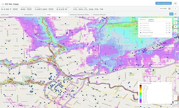
 This image shows an accumulation analysis for a hypothetical insurance portfolio in the Houston area. The inundation footprint from Hurricane Harvey generated by the new U.S. Inland Flood Model containing water depths in 14 bands is overlaid on the portfolio. (Image provided by Risk Management Solutions)
It is not even a year since Hurricane Harvey delivered catastrophic and unprecedented inland flooding across southeast Texas and parts of southern Louisiana. Most of the Houston Metropolitan area, with a population around 6.3 million, was significantly impacted as flood depths reached up to 12 feet (3.66 meters) in places.
Want to continue reading?
Become a Free PropertyCasualty360 Digital Reader
Your access to unlimited PropertyCasualty360 content isn’t changing.
Once you are an ALM digital member, you’ll receive:
- All PropertyCasualty360.com news coverage, best practices, and in-depth analysis.
- Educational webcasts, resources from industry leaders, and informative newsletters.
- Other award-winning websites including BenefitsPRO.com and ThinkAdvisor.com.
Already have an account? Sign In
© 2024 ALM Global, LLC, All Rights Reserved. Request academic re-use from www.copyright.com. All other uses, submit a request to [email protected]. For more information visit Asset & Logo Licensing.


